The City of North Battleford is concerned about riverbank erosion near the well field for Water Treatment Plant No. 1.
The issue came up at a Planning Committee on Monday. Water Treatment Plant No. 1 is the groundwater plant located just west of the Highway 16 bridges, and it relies on water wells along the riverbank to source water for the plant.
Mayor David Gillan recommended putting something in the city’s five-year plan to address the situation on the riverbank.
“It’s been delayed for a decade or more,” said Gillan. “I think the time has come to start dealing with it.”
A memo on the situation was provided by Director of City Operations Stewart Schafer, who also provided council with a technical report done by SG1 Water Consulting Ltd.
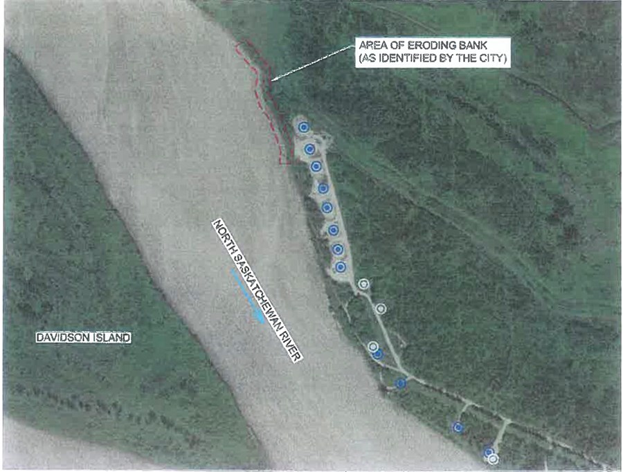
The main concern is an area along a bank on the northeast side of the North Saskatchewan River, not far from several of the city’s groundwater wells.
The report from SG1 states the river channel is progressing in an easterly direction towards their most upstream groundwater well on the northeast side of the river.
Of greater concern, as outlined in the report, is what could potentially happen with nine active groundwater wells situated upstream further to the east, with the potential for those locations to be at risk due to the erosion.
“This has been going on for some time,” said Schafer, noting this has been an issue going on decades. The city had tried putting riprap in (clean concrete) years ago at the location, but it didn’t work, he said.
The indication from SG1 is there may be some ways available to address the erosion. Some of those options will cost money, but it is not an urgent need. The report indicates the city has to address the issue by 2030.
The report outlined four potential options the city is looking at.
One is extensive riprap bank protection, where some well-graded rock riprap is placed on the banks over an overall length of about 655 meters. This would come at a construction price tag of around $1.64 million.
A second option is strategic placement of a series of what is described as river-training spur dykes, which would extend to the top of the riverbank and project into the river channel. The estimate is around $564,000.
The third option is a setback trench and localized riprap bank protection. The estimate would be around $788,000.
The fourth option is the “do nothing” approach for the time being, which would allow the channel to keep migrating in an easterly direction. While there is no construction “price tag” for this option, the city would need to budget for surveying and field monitoring for the riverbank.
The indication from Schafer is that administration is reviewing the report along with SG1 to determine the right option for the city, and that is still ongoing.
Mayor Gillan thought the localized riprap might be a good idea and more cost effective. But final decisions are still a long way off.


